The History Page provides a history of Kooyongkoot – both pre- and post- European settlement.
Our First People
The Kulin Nation
The area around Melbourne has been inhabited for an estimated 40,000 – 60,000 years before European settlement – which commenced less than 200 years ago in the 1830s. This is the domain of the Kulin Nation – an alliance of five indigenous “language groups” more-or-less centred on today’s Melbourne who shared related languages. Their collective territory extends around both Port Phillip Bay and Western Port – and north into the Great Dividing Range. In terms of today’s place names, the area includes Melbourne, Geelong, Bendigo, Ballarat, Maryborough, Wilsons Promontory and along the Loddon and Goulburn River valleys.
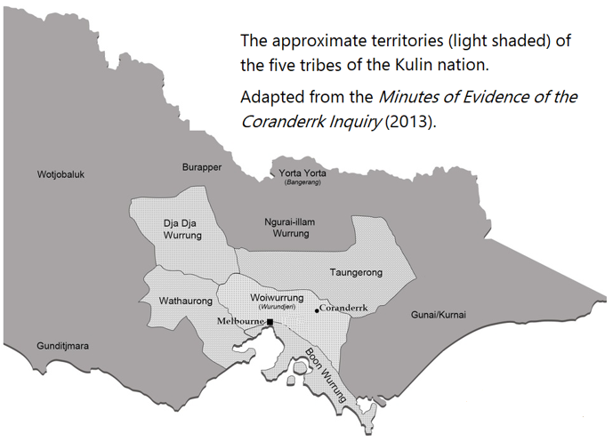
The Kulin people were “hunter-gatherers” who moved around within their territories relying on local vegetation and animals for their existence. When men married, they were obliged to take their partners from outside their clan and from as far away as possible. For example, marriages often involved partners from either side of the Great Dividing Range. This had the obvious benefit of limiting in-breeding but also helped maintain relationships with neighbouring groups through kinship ties.
KooyongKoot
Most of the KooyongKoot catchment falls within the Woiwurrung group’s area though the southernmost areas fall within the Boon Wurrung area. Part of the Scotchman’s Creek catchment lies just within the northern limits of Bunurong territory. Both tribes are part of the Kulin Nation. Wurrung means tongue – hence language – about 90% of words are common between the Woi Wurrung and Boon Wurrung languages (for example).
Clans
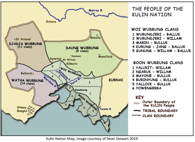
A number of clans comprised each language group. The clans “owned” areas of territory and were, in turn, comprised of family groups or “bands” who lived within those territories. [Note – the translations of language into English are different in the two maps above – please be aware that Daung Wurrung=Taungerong and Woi Wurrung = Woiwurrung]
The Wurundjeri are clans of the Woi Wurrung speaking group to the north and east of today’s Melbourne whose territory included the Birrarung (Yarra) Valley and its catchment including most of our KooyongKoot catchment. The southernmost reaches of the KooyongKoot catchment are recognised as Boonurong (Boon Wurrung speaking) lands.
Managing “Country”
It is wrong to think of the clans as totally nomadic. Although somewhat controversial, there is evidence that local aboriginal people engaged in sophisticated land management practices while looking after “country”. One local example is the cultivation and management of the locally indigenous Yam Daisy (Microseris walteri formerly Microseris lanceolata) and lilies whose nutritious tubers were gathered by the women using digging sticks. Managed “cultural burns” (as they are called today) were done in 3-4 year cycles which fertilized the soil allowing for the renewal of plant food sources for both humans and animals – and which maintained an open woodland conducive to animal hunting by the men.
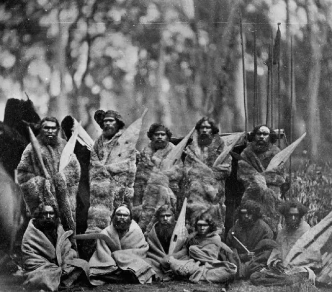
On the Cusp
The photo below shows Kulin men with traditional weapons and hunting tools. It was taken not long after Melbourne began in the 1830s. Notice that those standing are wearing traditional possum skin cloaks while those sitting are using (European) blankets.
Early European Settlement
The age of the squatter
From 1830-1840, European squatters moved out from Melbourne and built rough dwellings on land to the east where, as pastoralists, they raised cattle and sheep on natural grasslands. They did not own the land – they occupied it under licence from the Crown.
“KooyongKoot” means “place of the water fowl” and most likely refers to the swampy area at the creek’s junction with the Yarra.
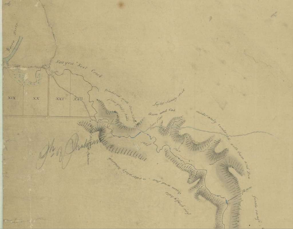
The above snippet excerpted from an early plan (surveyed by T.H. Nutt, October 1840) showing topographic features records that KooyongKoot ended in a swamp before meeting the Yarra. The creek feeding the swamp is named “Kooyon Koot Creek”.
Early settler, pastoralist and banker, John Gardiner (for whom the creek is now named), established a settlement near the junction of the Yarra and Gardiners Creek in 1837 after cattle were driven through there a year earlier. Much of Hawthorn was his original cattle run! Gardiner’s homestead is called “Kooyongkoot” on surveyor Robert Hoddle’s early plans for Melbourne. Hoddle is best known for his design of the very orderly layout of the CBD of Melbourne (now known as the Hoddle Grid).
Land Sales
By 1841, Melbourne’s population was 4,500 and land on the city fringes was fetching between £5 and £40 per acre. From 1848 onwards, pastoralists were able to buy the land they occupied. For example, the Bennett family bought over 100 acres near Gardiners Creek in the area now known as Bennettswood.
Prior to European settlement, the KooyongKoot Catchment would have sustained a rich and varied mixture of vegetation and wildlife. Most of the area further east was still native forest that attracted woodcutters who cut, carted and sold the wood in Melbourne for building houses, fences and for firewood. A thriving charcoal industry also existed in the area. The larger Eucalyptus and Acacias would have dominated the upper storey, supported by dense thickets of Swamp Paperbark and Bursaria. The ground storey would have featured native grasses, creepers and wildflowers, with reeds and rushes alongside the creek and wetlands.
The significant removal of vegetation began with the tree cutting, charcoal burning, mixed farming and grazing activities of the district’s early settlers.
Later European Settlement
The Gold Rush & its impacts
The discovery of gold in various parts of Victoria in the 1850s attracted many people to Melbourne resulting in the establishment of more farms to grow produce to feed the population. The Parish of Nunawading (the City of Whitehorse today) was surveyed and small farming allotments of 20-40 acres were offered for sale in the 1850s. “Nunawading” is translated variously as ‘meeting place’, ‘battlefield’ and ‘ceremonial ground’.
The map excerpt below (modern Box Hill South) shows the pattern of land selection that developed:
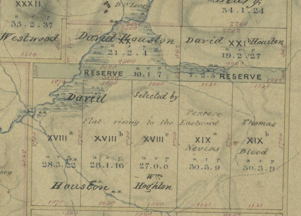
The dotted lines are dray tracks – even though it seems land was reserved for later roads in the subdivision. Interestingly, the map shows quite large swampy areas along KooyongKoot in David Houston’s land. This is where the famous “artists’ camp” was sited – in the summer of 1885/1886, Tom Roberts and Frederick McCubbin set up a tent on David Houston’s property, about a mile south of the Box Hill railway station. At the time, the area was relatively untouched bush. The site was used for “plein air” painting by artists who were part of the movement that later became known as the “Heidelberg School”. There is now a marker near the tees on the 15th and 17th holes of the Box Hill golf course showing where the camp was.
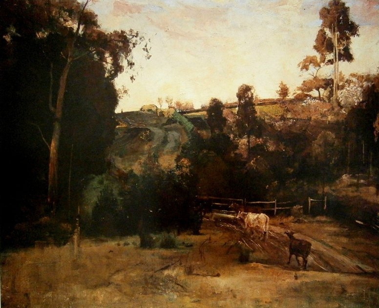
In Blacks Walk (part of the Blackburn Creeklands) on Middleborough Road near the junction with today’s Albion Road, there is a sign showing a reproduction of the Tom Roberts painting Dewy Eve (c.1888) with commentary referring to the artists hurrying back to Box Hill Station on Sunday nights after spending their weekends at the Houston property. The painting is thought to depict the area where Gardiners Creek crosses Middleborough Road. If so, Blacks Walk would be on the right-hand-side of the painting and the cattle would be replaced by today’s relentless streams of traffic.
Farming
In 1865, a new Land Act was passed to allow people (known as tenant farmers) to obtain annual licences to farm small 20-acre blocks. In 1869, these farmers were allowed to purchase the land they farmed if certain improvements had been made. These farmers were called “selectors”.
In 1866, White Horse Road was declared as a main road to connect with Lilydale to the east.
From the 1870s onwards, fruit orchards and flower farms began to proliferate, reaching a peak in the 1920s. Apples, pears, plums, cherries, apricots, lemons, peaches and quinces were grown and harvested, mostly as fresh fruit to feed the population of Melbourne. In 1889, Kooyongkoot Creek was dammed to form Blackburn Lake to provide more secure water for local fruit growers.
In 1882, the railway line was extended from Camberwell to Lilydale and the new Box Hill and Blackburn railway stations were opened. In 1888, the railway line to Box Hill was duplicated and, by 1891, the track duplication extended to Ringwood.
Several cool-stores were built to allow the storage of fruit for export eg the Blackburn Cool Stores opened next to the railway line in 1917. The Fankhauser family were pioneer orchardists in the East Burwood/Forest Hill area in the 1880s. The fruit was loaded onto horse-drawn drays and transported daily to the Queen Victoria Market in Melbourne where it was sold by the orchardists themselves. Richard Fankhauser opened a cool-store in East Burwood in 1912.
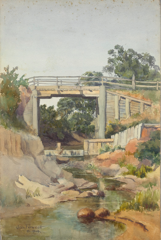
Glen Iris Road Bridge over Kooyong Koort Creek
James Fawcett (1863 – 1934)
Painted: September, 1894.
Courtesy: State Library, Victoria
The creek is underground there nowadays. Interestingly, the bridge seems to have been built very high – presumably to avoid being put out of action by flooding.
“Kooyong Koort” is the artist’s spelling of “KooyongKoot”.
The Modern Era
Pre World War 2
Urban development continued eastwards in the early twentieth century with tramways providing accessibility in addition to the railway network. For example:
- 1916 – a new tramway extended along Toorak Road to Warrigal Road.
- 1917 – another tramway along Riversdale Road was opened to the new Wattle Park at Warrigal Road (and then on to Elgar Road by 1928).
Taking the Shire of Nunawading (now the City of Whitehorse) as an example, by 1922, the orchard industry had peaked and then declined with residential development and the extension (and electrification) of the railway line further east. However, away from the railway line, the orchards in Burwood and Blackburn South continued to thrive for a few more decades.
During the 1930s:
- The Blue Moon Fruit Co-operative Limited was established in Blackburn to store, pack and distribute fruit for the burgeoning export market. This facility also proved useful in providing food for the services during WWII.
- The flower industry thrived after the Depression of the early 1930s because people could again afford to buy flowers. Ernest Albers grew daffodils and other bulbs on his 10-acre farm on Burwood Highway from 1934.
- Poultry farmers proliferated – with some specializing in breeding and hatcheries.
In relation to the KooyongKoot catchment, urbanisation of the inner suburbs that were well served by public transport was substantially complete before WWII.
From Trove – Second World War Volunteer Defence Corps battle practice in the so-called “Blackburn Woods” in 1942-44.

Post World War 2
After WWII, urbanization of remaining parts of the catchment took place generally to the east over time. Agriculture like fruit-growing quickly declined in the face of large profits to be made from the demand for land for housing.
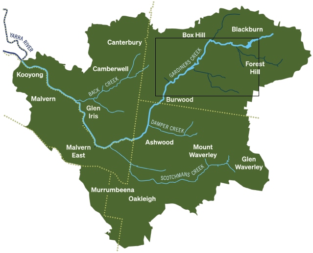
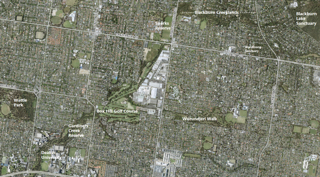
We look at aerial photographs of the rectangular area shown on the catchment map to see this process in transition from 1945 to 2022. The photos are snapshots from the aerial photos available on the Whitehorse Maps site.
The photos below show the northeast of the KooyongKoot catchment – with Blackburn Lake in the top right corner and the site of the future PLC college on Burwood Highway in the lower left. KooyongKoot creek can be seen wending its way westwards from the lake to Middleborough Road and then SSW and SW to the Burwood Highway.
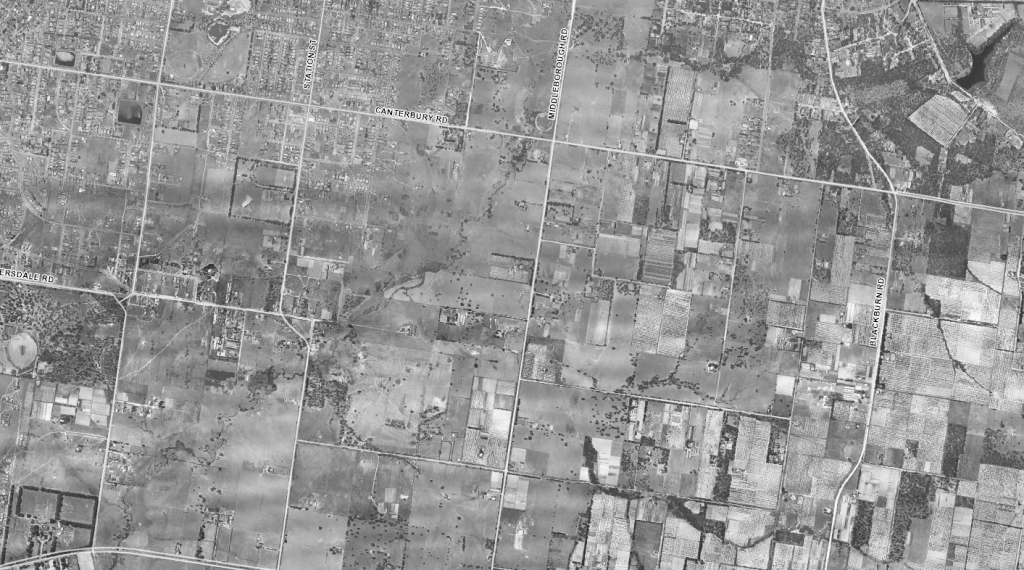
In 1945, most of the land to the south of the creek remained agricultural – for grazing or horticulture. Trees follow the creek as it wends its way between the orchards and pasture areas – otherwise most of the land has been cleared. Urban development had already extended to Box Hill and Surrey Hills.
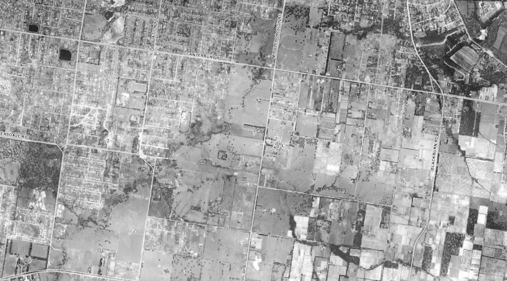
By 1951, the march of post-WWII urban development has seemingly been contained by the creek, with the suburbs of Burwood and Box Hill South developing rapidly. Those dark rectangles towards the top left are water reservoirs.
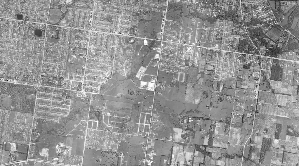
By 1956, housing had begun “filling the blanks” on the south side of the creek in Blackburn and Burwood East and with early signs of both the industrial area on Middleborough Rd and Blackburn South’s development taking shape. The Burwood Teachers’ College/Burwood High School complex had started up just to the east of the future PLC whose development also seems to have started.
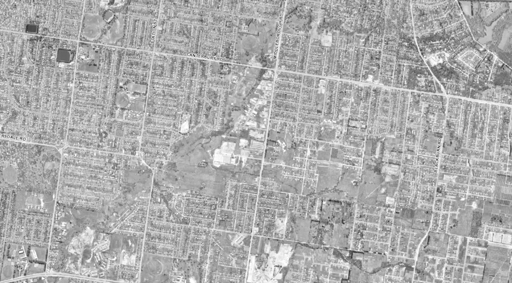
By 1963, most of the blanks had been filled in with urbanisation more or less complete – that’s a paper tissue mill developing in the centre of the photo and the Burwood Brickworks at the bottom centre.
By 2022 (approximating the current situation), the Burwood Brickworks has become a shopping centre and Deakin University has boomed subsuming the Burwood Teachers’ College/Burwood High School complex.
Perhaps counter-intuitively, the vegetation along the creek has visibly improved since 1945. Although some remnant vegetation was left along the creek, the land clearing for timber and producing coke in the early days, followed later by agriculture and urban development, left not much more than a blank slate except in special cases like parts of the Blackburn Lake Sanctuary. We have the local Councils, Melbourne Water (including its predecessors such as the MMBW) and many volunteers to thank for their foresight, expertise and efforts. Of course, the KKA exists to facilitate the continuation of this valuable and necessary work.
The Damper and Scotchmans Creek Sub-Catchments
A similar development process occurred in today’s City of Monash with Ashwood developing in the 1950s (accelerated by a large Housing Commission estate), Mount Waverley in the 1950/60s and Glen Waverley in the 1960/70s – even though the railway line connecting Glen Waverley to Melbourne was opened in 1930.
Acknowledgments:
This page includes material sourced from the former Wurundjeri Walk Advisory Committee’s History of Wurundjeri Walk web-site with the kind permission of the authors Sally Polack and David Berry, from the Blackburn Creeklands web-site with permission of the author John McMahon and several other local sources. We thank all for their cooperation in this work.
Request:
We are very interested in obtaining photographs and local histories of sites along KoogyongKoot and elsewhere in its catchment. Please let us know if you can help.
Other Resources
Presentation by Gary Presland on the history of KooyongKoot
The Source of KooyongKoot ?
Some of our Blackburn members disagree with Gary when he claims that Gardiners Creek commences at the confluence of two creeks in Blacks Walk in Blackburn – an “unnamed” creek headed north and “Blackburn Creek” headed eastwards in the early part of his talk. They argue that it is “Blackburn Creek” that heads northwards and Gardiners Creek continues eastwards towards what is now Blackburn Lake.
The map below shows Blackburn’s central water courses on this excerpt from the 1864 Nunawading parish plan:
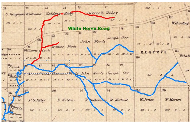
To support their case, the locals argue that:
- The original name for “Blackburn” was “Blackburn Creek”.
- The first significant building in the Blackburn area was a hotel on “White Horse” Road, built in 1861, where Blackburn Creek crossed the road. Blackburn Creek must therefore be the red-coloured water course. It also had a small tributary that ran more-or-less along South Parade just south of today’s Blackburn railway station.
- The Blackburn Creek Post Office opened in 1876 and was renamed Blackburn in 1883.
Further evidence appears in this detailed survey conducted by the MMBW in 1938:
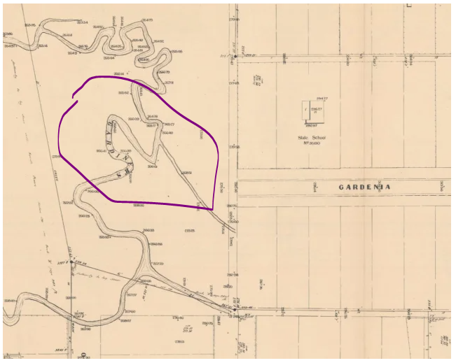
This clearly shows the creek labelled as “Gardiners” in Furness Park to the south of Gardenia Street, Blackburn. Furness Park is on the opposite, eastern side of the Blackburn Creeklands to Blacks Walk.